Bought with Patty Helton Davis • PHD Real Estate, LLC
$25,000
$52,432
52.3%For more information regarding the value of a property, please contact us for a free consultation.
43.69 Acres Lot
SOLD DATE : 03/05/2021
Key Details
Sold Price $25,000
Property Type Vacant Land
Sub Type Land/Acreage
Listing Status Sold
Purchase Type For Sale
MLS Listing ID 578265
Sold Date 03/05/21
HOA Y/N No
Originating Board Pensacola MLS
Lot Size 43.693 Acres
Acres 43.6931
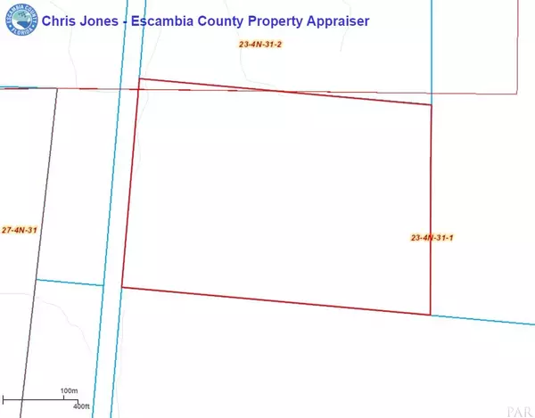
Lot Dimensions 1159x1464x1135x1507
Property Description
McDavid, FL- No legal access, but there is a Rail Road that runs along the west boundary line of this 43.69 acres of beautifully wooded land in the desirable McDavid, Florida area. The topography of this property makes it ideal from the main road for all the peace and privacy you desire. Hunt on your own property, deer, turkey, squirrels, birds.. have a garden and bring the horses. Plenty of acreage to enjoy the outdoors. THIS PROPERTY IS IN A SPECIAL FLOOD HAZARD AREA, AE.. Plus camping, boating, fishing, canoeing, hiking, wildlife viewing and seasonal hunting at the Northwest Florida Management Area and Mystic Springs Rec. Their boat ramp provides access to the Escambia River, which is popular for swimming and fishing. With this property you can truly have it all! Call today to submit your offer! The Northwest Florida Water Management District stretches from the St. Marks River Basin in Jefferson County to the Perdido River in Escambia County. The District is one of five water management districts in Florida created by the Water Resources Act of 1972. *Use GPS Address 501 E BOGIA RD which is on the left. This property is on the right. Will be difficult to locate due to the over growth and no legal access.
Location
State FL
County Escambia
Zoning Agricultural,County,Horses Allowed,Mobile Homes,Res Single
Exterior
Utilities Available Natural Gas Not Available, Electricity Connected, Phone Connected
Waterfront Description No Waterfront, No Waterfront Features
View Y/N No
Building
Lot Description Wooded, Interior Lot, No Improvements
Faces From Atmore, AL/FL line: Start out going southeast on S Main St/AL-21 toward S Presley St Crossing into FL. S Main St/AL-21 becomes Hwy 97. In 2.5 mi turn left onto W Hwy 4. In 9.7 mi turn right onto Byrneville Rd. In 2 mi turn left to stay on Byrneville Rd. In 0.7 mi take the 1st right onto Crary Rd. In 1 mi turn right onto N Century Blvd. In 6 mi turn left onto E Bogia Rd. GPS Address 501 E BOGIA RD is on the left. Property on your right. Will be difficult to locate due to no legal access.
Water None
New Construction No
Others
Tax ID 374N311104003006
Read Less Info
Want to know what your home might be worth? Contact us for a FREE valuation!

Our team is ready to help you sell your home for the highest possible price ASAP


